Geolocate

Homer topographic map

Click on the map to display elevation.

About this map

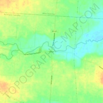
Name: Homer topographic map, elevation, terrain.

Location: Homer, Burlington Township, Licking County, Ohio, United States (40.23265 -82.53879 40.27265 -82.49879)

Average elevation: 311 m

Minimum elevation: 294 m

Maximum elevation: 328 m

Other topographic maps

Click on a map to view its topography, its elevation and its terrain.

Hartford

United States > Ohio > Licking County

Average elevation: 353 m

Granville South

United States > Ohio > Licking County

Average elevation: 314 m

Granville Township

United States > Ohio > Licking County

Average elevation: 317 m

Pataskala

United States > Ohio > Licking County

Average elevation: 332 m

Harrison Township

United States > Ohio > Licking County

Average elevation: 320 m

Madison Township

United States > Ohio > Licking County

Average elevation: 273 m

Gratiot

United States > Ohio > Licking County

Average elevation: 296 m

Mary Ann Township

United States > Ohio > Licking County

Average elevation: 303 m

Etna Township

United States > Ohio > Licking County

Average elevation: 311 m

Alexandria

United States > Ohio > Licking County

Average elevation: 299 m

Newark Earthworks

United States > Ohio > Licking County > Heath

Average elevation: 262 m

McKean Township

United States > Ohio > Licking County

Average elevation: 345 m

Gear up for your next adventure:

🔭Compact Binoculars - Lightweight optics for scouting trails and wildlife
💡Compact LED Flashlight - Powerful and portable flashlight for outdoor use
🧥Softshell Hiking Jacket - The perfect balance of wind protection and breathability
🧥Insulated Jacket - Keep warm in cold outdoor conditions
🧼Travel Hand Sanitizer - Keep hands clean when water is scarce

As an Amazon Associate, this site earns from qualifying purchases at no extra cost to you.