
Thank you for supporting this site ❤️
Make a donation
Make a donation
Gear up for your next adventure:
As an Amazon Associate, this site earns from qualifying purchases at no extra cost to you.
Paterna topographic map
Click on the map to display elevation.
Thank you for supporting this site ❤️
Make a donation
Make a donation
Gear up for your next adventure:
As an Amazon Associate, this site earns from qualifying purchases at no extra cost to you.
About this map
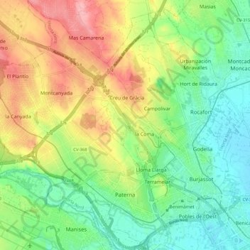
Name: Paterna topographic map, elevation, terrain.
Location: Paterna, l'Horta Nord, Valencianische Gemeinschaft, Spanien (39.48637 -0.51869 39.56538 -0.41854)
Average elevation: 69 m
Minimum elevation: 18 m
Maximum elevation: 147 m
Thank you for supporting this site ❤️
Make a donation
Make a donation
Gear up for your next adventure:
As an Amazon Associate, this site earns from qualifying purchases at no extra cost to you.
Other topographic maps
Click on a map to view its topography, its elevation and its terrain.
Benimaurell
Spanien > Valencianische Gemeinschaft > la Vall de Laguar > Benimaurell
Average elevation: 495 m