
Make a donation
Gear up for your next adventure:
As an Amazon Associate, this site earns from qualifying purchases at no extra cost to you.
Cerami topographic map
Click on the map to display elevation.
Make a donation
Gear up for your next adventure:
As an Amazon Associate, this site earns from qualifying purchases at no extra cost to you.
About this map
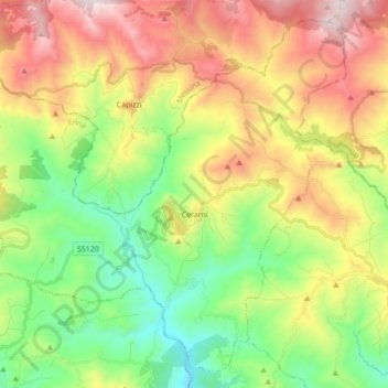
Name: Cerami topographic map, elevation, terrain.
Location: Cerami, Enna, Sicilia, 94010, Italia (37.75529 14.40307 37.88009 14.57398)
Average elevation: 925 m
Minimum elevation: 498 m
Maximum elevation: 1,540 m
Make a donation
Gear up for your next adventure:
As an Amazon Associate, this site earns from qualifying purchases at no extra cost to you.
Other topographic maps
Click on a map to view its topography, its elevation and its terrain.
Pergusa
Italia > Sicilia > Enna > Enna
Pergusa si sviluppa circa 5 km a sud del monte Enna, tra verdeggianti e dolci colline a un'altitudine variabile tra i 610 e i 750 m sul livello del mare. Il Villaggio si specchia sulle rive del suggestivo lago Pergusa, l'unico lago naturale della Sicilia.
Average elevation: 697 m
Make a donation
Gear up for your next adventure:
As an Amazon Associate, this site earns from qualifying purchases at no extra cost to you.
Make a donation
Gear up for your next adventure:
As an Amazon Associate, this site earns from qualifying purchases at no extra cost to you.