Geolocate

Llanuces topographic map

Click on the map to display elevation.

About this map

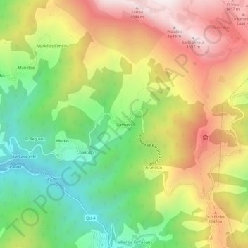
Name: Llanuces topographic map, elevation, terrain.

Location: Llanuces, Quirós, Asturias, 33117, España (43.13524 -5.94411 43.17524 -5.90411)

Average elevation: 991 m

Minimum elevation: 500 m

Maximum elevation: 1,553 m

Gear up for your next adventure:

💡Compact LED Flashlight - Powerful and portable flashlight for outdoor use
💧Collapsible Water Bottle - Space-saving water bottle for outdoor activities
🥾Trekking Poles - Adjustable trekking poles to reduce knee stress and improve stability
🚑Survival Whistle - Signal for help across long distances in mountains
Family Camping Tent - Spacious tent suitable for family camping trips

As an Amazon Associate, this site earns from qualifying purchases at no extra cost to you.