Geolocate

Cotahuma topographic map

Click on the map to display elevation.

About this map

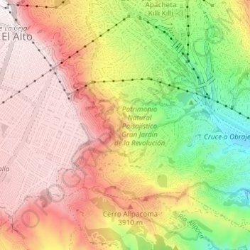
Name: Cotahuma topographic map, elevation, terrain.

Location: Cotahuma, La Paz, Pedro Domingo Murillo, La Paz, Bolivia (-16.55441 -68.15668 -16.49639 -68.11534)

Average elevation: 3,746 m

Minimum elevation: 3,303 m

Maximum elevation: 4,104 m

Gear up for your next adventure:

🥽Outdoor Goggles - Protective eyewear for outdoor activities
🩹Moleskin Blister Pads - Direct protection for painful foot pressure points
🧣Merino Neck Gaiter - Protects against wind, sun, and cold at high altitudes
Lightweight Backpacking Tent - Compact tent for efficient hiking trips
🧥Ultralight Puffy Jacket - Maximum warmth that packs down to the size of an orange

As an Amazon Associate, this site earns from qualifying purchases at no extra cost to you.