Geolocate

Bug topographic map

Click on the map to display elevation.

About this map

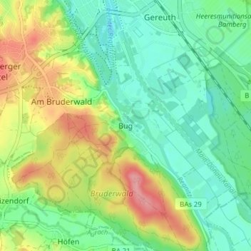
Name: Bug topographic map, elevation, terrain.

Location: Bug, Bamberg, Bayern, 96050, Deutschland (49.84552 10.88891 49.88552 10.92891)

Average elevation: 264 m

Minimum elevation: 229 m

Maximum elevation: 325 m

Other topographic maps

Click on a map to view its topography, its elevation and its terrain.

96047

Deutschland > Bayern > Bamberg

Average elevation: 254 m

96052

Deutschland > Bayern > Bamberg

Average elevation: 261 m

Gear up for your next adventure:

🔭Compact Monocular - One-handed bird watching and trail spotting
🧢Outdoor Cap - Protective cap for sun and rain during hikes
💡LED Headlamp - Hands-free illumination for night hiking and camping
🥽Outdoor Goggles - Protective eyewear for outdoor activities
🥾Waterproof Hiking Boots - Essential footwear for rugged terrain and wet Canadian trails

As an Amazon Associate, this site earns from qualifying purchases at no extra cost to you.