
Make a donation
Gear up for your next adventure:
As an Amazon Associate, this site earns from qualifying purchases at no extra cost to you.
Mirandol topographic map
Click on the map to display elevation.
Make a donation
Gear up for your next adventure:
As an Amazon Associate, this site earns from qualifying purchases at no extra cost to you.
About this map
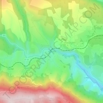
Name: Mirandol topographic map, elevation, terrain.
Average elevation: 1,204 m
Minimum elevation: 1,028 m
Maximum elevation: 1,445 m
Make a donation
Gear up for your next adventure:
As an Amazon Associate, this site earns from qualifying purchases at no extra cost to you.
Other topographic maps
Click on a map to view its topography, its elevation and its terrain.
Chasseradès
France > Occitanie > Lozère > Mont Lozère et Goulet
Situé sur les pentes du mont Goulet à 1240 m d'altitude, Serreméjan est un ancien hameau aujourd'hui désert et en ruines.
Average elevation: 1,242 m
Make a donation
Gear up for your next adventure:
As an Amazon Associate, this site earns from qualifying purchases at no extra cost to you.
Ruisseau de Coufoulens
France > Occitanie > Lozère > Mont Lozère et Goulet > Saint-Frézal-d'Albuges > La Peyre
Average elevation: 1,215 m