Geolocate

Collegno topographic map

Click on the map to display elevation.

About this map

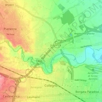
Name: Collegno topographic map, elevation, terrain.

Location: Collegno, Torino, Piedmont, Italy (45.06918 7.55469 45.12018 7.62288)

Average elevation: 300 m

Minimum elevation: 259 m

Maximum elevation: 350 m

Gear up for your next adventure:

🗺️Topographic Maps - Detailed maps to explore trails, mountains, and wilderness areas
🥾Mountain Trail Shoes - High-traction shoes for mountain trails
🧊Insulated Water Bottle - Keeps drinks cold in summer and prevents freezing in winter
🔪Outdoor Multitool - Versatile tool for repairs and food prep in the wild
🎒Backpack Rain Cover - External shield to keep your entire pack dry

As an Amazon Associate, this site earns from qualifying purchases at no extra cost to you.