Geolocate

Goizueta topographic map

Click on the map to display elevation.

About this map

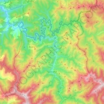
Name: Goizueta topographic map, elevation, terrain.

Location: Goizueta, Larraun-Leitzaldea, Navarre, 31754, Spain (43.14063 -1.92069 43.24686 -1.76044)

Average elevation: 441 m

Minimum elevation: 27 m

Maximum elevation: 1,027 m

Other topographic maps

Click on a map to view its topography, its elevation and its terrain.

Ear

Spain > Navarre > Larraun-Leitzaldea > Larraun

Average elevation: 824 m

Gear up for your next adventure:

💧Filtered Water Bottle - Safe drinking water on the go
🧭GPS Tracker - Track your location in remote areas safely
🩹Compact First Aid Kit - Pre-packed essentials for common trail injuries
🛁Quick-Dry Microfiber Towel - Space-saving towel that dries rapidly on the move
🥾Hiking Gaiters - Protect legs and shoes from mud, snow, and debris

As an Amazon Associate, this site earns from qualifying purchases at no extra cost to you.