
Make a donation
Gear up for your next adventure:
As an Amazon Associate, this site earns from qualifying purchases at no extra cost to you.
Neuenhaus topographic map
Click on the map to display elevation.
Make a donation
Gear up for your next adventure:
As an Amazon Associate, this site earns from qualifying purchases at no extra cost to you.
Neuenhaus
Im Jahr 1542 wurde der Ort das erste Mal urkundlich in den Türkensteuerlisten unter der Ortsbezeichnung „Nyenhuyß“ erwähnt. In der Preußischen Uraufnahme von 1840 lautet der Ortsname „Neuhaus“. Ab der topografische Karte (Preußische Neuaufnahme) von 1894 bis 1896 lautet die Ortsbezeichnung „Neuenhaus“.
Make a donation
Gear up for your next adventure:
As an Amazon Associate, this site earns from qualifying purchases at no extra cost to you.
About this map
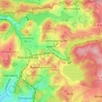
Name: Neuenhaus topographic map, elevation, terrain.
Average elevation: 373 m
Minimum elevation: 289 m
Maximum elevation: 445 m
Make a donation
Gear up for your next adventure:
As an Amazon Associate, this site earns from qualifying purchases at no extra cost to you.