
Thank you for supporting this site ❤️
Make a donation
Make a donation
Gear up for your next adventure:
As an Amazon Associate, this site earns from qualifying purchases at no extra cost to you.
Ayahuasi topographic map
Click on the map to display elevation.
Thank you for supporting this site ❤️
Make a donation
Make a donation
Gear up for your next adventure:
As an Amazon Associate, this site earns from qualifying purchases at no extra cost to you.
About this map
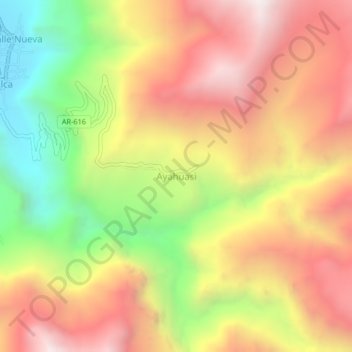
Name: Ayahuasi topographic map, elevation, terrain.
Location: Ayahuasi, Alca, La Unión, Arequipa, Perú (-15.16501 -72.76459 -15.12501 -72.72459)
Average elevation: 3,518 m
Minimum elevation: 2,722 m
Maximum elevation: 4,189 m
Thank you for supporting this site ❤️
Make a donation
Make a donation
Gear up for your next adventure:
As an Amazon Associate, this site earns from qualifying purchases at no extra cost to you.