Geolocate

Akhtala topographic map

Click on the map to display elevation.

About this map

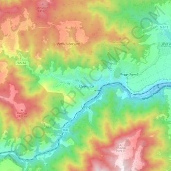
Name: Akhtala topographic map, elevation, terrain.

Location: Akhtala, Alaverdi community, Lori Province, Armenia (41.10816 44.72980 41.18816 44.80980)

Average elevation: 1,000 m

Minimum elevation: 540 m

Maximum elevation: 1,633 m

Other topographic maps

Click on a map to view its topography, its elevation and its terrain.

Verin Akhtala

Armenia > Lori Province

Average elevation: 1,154 m

Alaverdi

Armenia > Lori Province

Average elevation: 1,063 m

Vanadzor

Armenia > Lori Province

Average elevation: 1,670 m

Stepanavan

Armenia > Lori Province

Average elevation: 1,434 m

Vanadzor

Armenia > Lori Province > Vanadzor

Average elevation: 1,678 m

Gyulagarak

Armenia > Lori Province

Average elevation: 1,387 m

Atan

Armenia > Lori Province

Average elevation: 1,699 m

Pambak community

Armenia > Lori Province

Average elevation: 1,914 m

Dsegh

Armenia > Lori Province

Average elevation: 1,181 m

Lernapat

Armenia > Lori Province

Average elevation: 1,585 m

Gear up for your next adventure:

🛏️Sleeping Bag - Warm and compact sleeping bags for outdoor camping
🛌Insulated Sleeping Pad - Critical thermal barrier between you and the cold ground
Family Camping Tent - Spacious tent suitable for family camping trips
🧭GPS Handheld Device - Reliable GPS navigation for outdoor adventures
🗺️Topographic Maps - Detailed maps to explore trails, mountains, and wilderness areas

As an Amazon Associate, this site earns from qualifying purchases at no extra cost to you.