
Thank you for supporting this site ❤️
Make a donation
Make a donation
Gear up for your next adventure:
As an Amazon Associate, this site earns from qualifying purchases at no extra cost to you.
Freienseen topographic map
Click on the map to display elevation.
Thank you for supporting this site ❤️
Make a donation
Make a donation
Gear up for your next adventure:
As an Amazon Associate, this site earns from qualifying purchases at no extra cost to you.
About this map
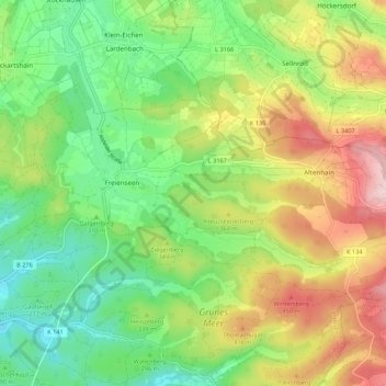
Name: Freienseen topographic map, elevation, terrain.
Location: Freienseen, Laubach, Landkreis Gießen, Hessen, Deutschland (50.53905 9.02250 50.57780 9.13046)
Average elevation: 331 m
Minimum elevation: 214 m
Maximum elevation: 510 m
Thank you for supporting this site ❤️
Make a donation
Make a donation
Gear up for your next adventure:
As an Amazon Associate, this site earns from qualifying purchases at no extra cost to you.
Other topographic maps
Click on a map to view its topography, its elevation and its terrain.
Wochenendgebiet Steinköppel
Deutschland > Hessen > Landkreis Gießen > Laubach
Average elevation: 433 m