
Make a donation
Gear up for your next adventure:
As an Amazon Associate, this site earns from qualifying purchases at no extra cost to you.
Anogia topographic map
Click on the map to display elevation.
Make a donation
Gear up for your next adventure:
As an Amazon Associate, this site earns from qualifying purchases at no extra cost to you.
About this map
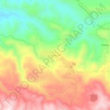
Name: Anogia topographic map, elevation, terrain.
Average elevation: 713 m
Minimum elevation: 420 m
Maximum elevation: 1,030 m
Make a donation
Gear up for your next adventure:
As an Amazon Associate, this site earns from qualifying purchases at no extra cost to you.
Other topographic maps
Click on a map to view its topography, its elevation and its terrain.
Municipality of Agios Vasileios
Greece > Region of Crete > Rethymno Regional Unit
Average elevation: 247 m
Myli Gorge
Greece > Region of Crete > Rethymno Regional Unit > Xiro Chorio > Myli
Average elevation: 198 m
Make a donation
Gear up for your next adventure:
As an Amazon Associate, this site earns from qualifying purchases at no extra cost to you.