Geolocate

Port Isabel topographic map

Click on the map to display elevation.

About this map
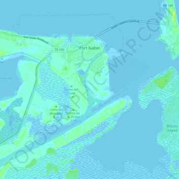
Name: Port Isabel topographic map, elevation, terrain.

Location: Port Isabel, Cameron County, Texas, 78578, United States (26.01561 -97.28843 26.08996 -97.18995)

Average elevation: 2 m

Minimum elevation: -3 m

Maximum elevation: 15 m

Other topographic maps

Click on a map to view its topography, its elevation and its terrain.
Laguna Heights

United States > Texas > Cameron County

Average elevation: 2 m

South Point

United States > Texas > Cameron County

Average elevation: 7 m

Arroyo City

United States > Texas > Cameron County

Average elevation: 5 m

Olmito

United States > Texas > Cameron County

Average elevation: 11 m

Palmer Colonia

United States > Texas > Cameron County

Average elevation: 15 m

Lozano

United States > Texas > Cameron County

Average elevation: 10 m

Lopez Colonia

United States > Texas > Cameron County > Rio Hondo

Average elevation: 10 m

Loma Plata

United States > Texas > Cameron County

Average elevation: 0 m

Gear up for your next adventure:

🥤Collapsible Travel Cup - Saves space and weight in your mess kit
🏃Hydration Running Vest - Carry water and maps close to your body for speed
🔦LED Headtorch - Bright and durable light for night activities
🔭Compact Monocular - One-handed bird watching and trail spotting
⛺Camping Tent - Weather-resistant tents suitable for 2 to 6 people

As an Amazon Associate, this site earns from qualifying purchases at no extra cost to you.