Geolocate

Tithal topographic map

Click on the map to display elevation.

About this map

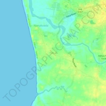
Name: Tithal topographic map, elevation, terrain.

Location: Tithal, Valsad Taluka, Valsad, Gujarat, 396001, India (20.56916 72.88424 20.60916 72.92424)

Average elevation: 7 m

Minimum elevation: 0 m

Maximum elevation: 20 m

Gear up for your next adventure:

🥾Trail Hiking Boots - Supportive boots for rough trails
🥾Mountain Hiking Shoes - Shoes with superior grip for mountainous terrain
🦯Trekking Poles - Reduced impact on joints for steep topographic climbs
🛏️Sleeping Bag - Warm and compact sleeping bags for outdoor camping
🚑Survival Whistle - Signal for help across long distances in mountains

As an Amazon Associate, this site earns from qualifying purchases at no extra cost to you.