Geolocate

Fuchsstadt topographic map

Click on the map to display elevation.

About this map

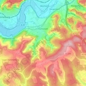
Name: Fuchsstadt topographic map, elevation, terrain.

Location: Fuchsstadt, Elfershausen (VGem), Landkreis Bad Kissingen, Bavaria, 97727, Germany (50.07054 9.90528 50.12711 9.96962)

Average elevation: 278 m

Minimum elevation: 175 m

Maximum elevation: 379 m

Other topographic maps

Click on a map to view its topography, its elevation and its terrain.

Ebenhausen

Germany > Bavaria > Landkreis Bad Kissingen

Average elevation: 308 m

Trübenbrunn

Germany > Bavaria > Landkreis Bad Kissingen

Average elevation: 359 m

Gear up for your next adventure:

🎒Backpack Rain Cover - External shield to keep your entire pack dry
🔥Camping Stove - Portable stoves to cook outdoors with ease
🧥Packable Rain Jacket - Breathable waterproof layer for unpredictable weather
🥾Mountaineering Boots - Supportive boots for climbing and high-altitude hiking
🧤Thermal Hiking Gloves - Grip-enhanced gloves for cold-weather altitude trekking

As an Amazon Associate, this site earns from qualifying purchases at no extra cost to you.