
Guggenberg topographic map
Click on the map to display elevation.
Guggenberg
Ottobeuren | Bäuerle | Betzisried | Bibelsberg | Böglins | Boschach | Brüchlins | Bühl | Daßberg | Dennenberg | Eggisried | Eheim | Eheimer Mühle | Eldern | Fröhlins | Geislins | Guggenberg | Gumpratsried | Gut | Hahnenbühl | Haitzen | Halbersberg | Hessen | Höhe | Hofs | Kloster Wald | Langenberg | Leupolz | Neuvogelsang | Niebers | Oberhaslach | Oberried | Ölbrechts | Ollarzried | Rempolz | Reuthen | Schachen | Schellenberg | Schiessenhof | Schochenhof | Schoren | Schrallen | Steeger | Stephansried | Unterhaslach | Unterschochen | Vogelsang | Wetzlins | Wolferts
About this map
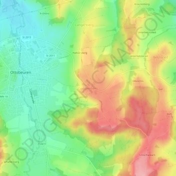
Name: Guggenberg topographic map, elevation, terrain.
Average elevation: 696 m
Minimum elevation: 636 m
Maximum elevation: 769 m
Other topographic maps
Click on a map to view its topography, its elevation and its terrain.