Geolocate

Sambuca topographic map

Click on the map to display elevation.

About this map

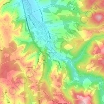
Name: Sambuca topographic map, elevation, terrain.

Location: Sambuca, Barberino Tavarnelle, Florence, Tuscany, 50028, Italy (43.54740 11.19727 43.58740 11.23727)

Average elevation: 269 m

Minimum elevation: 161 m

Maximum elevation: 383 m

Other topographic maps

Click on a map to view its topography, its elevation and its terrain.

Florence

Italy > Tuscany > Florence

Average elevation: 142 m

Florence

Italy > Tuscany > Florence

Average elevation: 142 m

Florence

Italy > Tuscany > Florence

Average elevation: 142 m

Greve in Chianti

Italy > Tuscany > Florence

Average elevation: 364 m

Calenzano

Italy > Tuscany > Florence

Average elevation: 300 m

Greve

Italy > Tuscany > Florence

Average elevation: 259 m

Bagno a Ripoli

Italy > Tuscany > Florence

Average elevation: 210 m

Fiesole

Italy > Tuscany > Florence

Average elevation: 265 m

Greve in Chianti

Italy > Tuscany > Florence

Average elevation: 364 m

Palazzuolo sul Senio

Italy > Tuscany > Florence

Average elevation: 655 m

Florence

Italy > Tuscany > Florence

Average elevation: 142 m

Montespertoli

Italy > Tuscany > Florence

Average elevation: 162 m

Florence

Italy > Tuscany > Florence

Average elevation: 142 m

Vicchio

Italy > Tuscany > Florence

Average elevation: 447 m

Certaldo

Italy > Tuscany > Florence

Average elevation: 128 m

Reggello

Italy > Tuscany > Florence

Average elevation: 584 m

Marradi

Italy > Tuscany > Florence

Average elevation: 672 m

Florence

Italy > Tuscany > Florence

Average elevation: 142 m

Certaldo

Italy > Tuscany > Florence

Average elevation: 128 m

Florence

Italy > Tuscany > Florence

Average elevation: 142 m

Fiesole

Italy > Tuscany > Florence

Average elevation: 265 m

Greve in Chianti

Italy > Tuscany > Florence

Average elevation: 364 m

Dicomano

Italy > Tuscany > Florence

Average elevation: 515 m

Firenzuola

Italy > Tuscany > Florence

Average elevation: 668 m

Pelago

Italy > Tuscany > Florence

Average elevation: 481 m

Signa

Italy > Tuscany > Florence

Average elevation: 48 m

Castelfiorentino

Italy > Tuscany > Florence

Average elevation: 98 m

Montaione

Italy > Tuscany > Florence

Average elevation: 186 m

Borgo San Lorenzo

Italy > Tuscany > Florence

Average elevation: 447 m

Vinci

Italy > Tuscany > Florence

Average elevation: 122 m

Londa

Italy > Tuscany > Florence

Average elevation: 575 m

Firenzuola

Italy > Tuscany > Florence

Average elevation: 668 m

Pontassieve

Italy > Tuscany > Florence

Average elevation: 364 m

Gear up for your next adventure:

🧢Beanie Hat - Keep your head warm in cold weather
🔨Vehicle Emergency Tool - Safety tool for remote road trips to trailheads
🧴Outdoor Sunscreen - High SPF protection for high-altitude UV exposure
🗺️Topographic Maps - Detailed maps to explore trails, mountains, and wilderness areas
Camping Essentials - All-in-one gear for a comfortable camping trip

As an Amazon Associate, this site earns from qualifying purchases at no extra cost to you.