
Huletts Landing topographic map
Click on the map to display elevation.
About this map
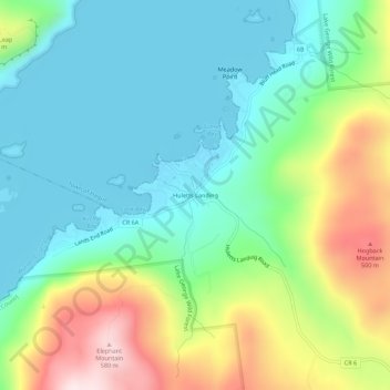
Name: Huletts Landing topographic map, elevation, terrain.
Average elevation: 245 m
Minimum elevation: 94 m
Maximum elevation: 588 m
Other topographic maps
Click on a map to view its topography, its elevation and its terrain.
Batten Kill
United States > New York > Washington County
Mad Tom Brook rises on the southern slope of Mount Tabor in the northwestern part of the town of Peru at an altitude of 2,900 feet (880 m) above sea level. It flows southward and south-westward to East Dorset where it joins the beginning of the Batten Kill from the north. Its length is about 5.5 miles (8.9…
Average elevation: 337 m
Fort Edward Feeder Canal
United States > New York > Washington County > Village of Fort Edward
Average elevation: 57 m