Geolocate

Craig topographic map

Click on the map to display elevation.

About this map

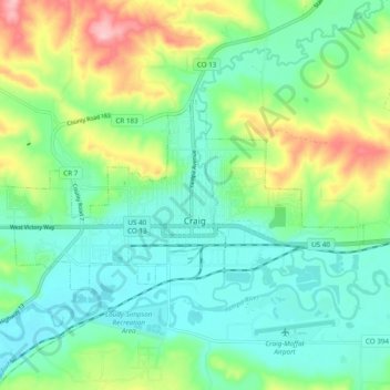
Name: Craig topographic map, elevation, terrain.

Location: Craig, Moffat County, Colorado, 81625, United States (40.50221 -107.60119 40.53800 -107.50454)

Average elevation: 1,923 m

Minimum elevation: 1,873 m

Maximum elevation: 2,043 m

Other topographic maps

Click on a map to view its topography, its elevation and its terrain.

Diamond Peak

United States > Colorado > Moffat County

Average elevation: 2,727 m

Schoonover Buttes

United States > Colorado > Moffat County

Average elevation: 1,902 m

Gear up for your next adventure:

💡Compact LED Flashlight - Powerful and portable flashlight for outdoor use
🕯️Camping Lantern - Illuminates your entire campsite with high-efficiency LEDs
👟Sport Hiking Sandals - Breathable footwear for water crossings and camp rest
🥾Waterproof Hiking Boots - Essential footwear for rugged terrain and wet Canadian trails
🚲Heavy Duty Bike Lock - Secure your bike at the trailhead or during stops

As an Amazon Associate, this site earns from qualifying purchases at no extra cost to you.