
Make a donation
Gear up for your next adventure:
As an Amazon Associate, this site earns from qualifying purchases at no extra cost to you.
Gundersleben topographic map
Click on the map to display elevation.
Make a donation
Gear up for your next adventure:
As an Amazon Associate, this site earns from qualifying purchases at no extra cost to you.
About this map
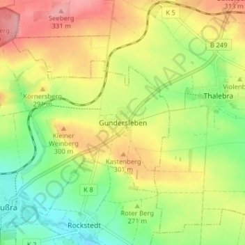
Name: Gundersleben topographic map, elevation, terrain.
Average elevation: 274 m
Minimum elevation: 222 m
Maximum elevation: 333 m
Make a donation
Gear up for your next adventure:
As an Amazon Associate, this site earns from qualifying purchases at no extra cost to you.
Other topographic maps
Click on a map to view its topography, its elevation and its terrain.
Thüringenhausen
Deutschland > Thüringen > Kyffhäuserkreis > Ebeleben
Thüringenhausen liegt in etwa 220 Meter Höhe über dem Meeresspiegel an einem Bogen der Helbe. Die Landschaft ist weitgehend durch landwirtschaftliche Nutzflächen geprägt; Baumbestand existiert lediglich in der Flussaue der Helbe sowie als Alleebäume entlang der Straßen. Ohne direkte Grenze zum…
Average elevation: 251 m