Geolocate

La Matosa topographic map

Click on the map to display elevation.

About this map

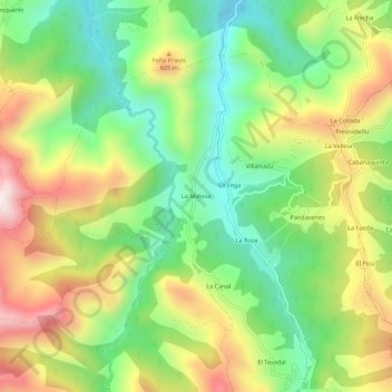
Name: La Matosa topographic map, elevation, terrain.

Location: La Matosa, Montes, Piloña, Asturias, España (43.29890 -5.28122 43.33890 -5.24122)

Average elevation: 424 m

Minimum elevation: 149 m

Maximum elevation: 804 m

Other topographic maps

Click on a map to view its topography, its elevation and its terrain.

Miyares

España > Asturias > Piloña

Average elevation: 221 m

Gear up for your next adventure:

💡LED Camping Lantern - Illuminate your campsite with long-lasting lanterns
🥾Trail Hiking Socks - Comfortable socks to prevent blisters and fatigue
🛏️Sleeping Bag - Warm and compact sleeping bags for outdoor camping
🔦LED Headlamp - Hands-free lighting for early morning starts or late finishes
🧭GPS Tracker - Track your location in remote areas safely

As an Amazon Associate, this site earns from qualifying purchases at no extra cost to you.