Geolocate

Jindalee topographic map

Click on the map to display elevation.

About this map

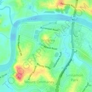
Name: Jindalee topographic map, elevation, terrain.

Location: Jindalee, Brisbane City, Queensland, Australia (-27.54402 152.92659 -27.52686 152.95055)

Average elevation: 23 m

Minimum elevation: -2 m

Maximum elevation: 74 m

Other topographic maps

Click on a map to view its topography, its elevation and its terrain.

Willmington Park

Australia > Queensland > Brisbane City

Average elevation: 37 m

Mount Gravatt

Australia > Queensland > Brisbane City

Average elevation: 70 m

Ithaca

Australia > Queensland > Brisbane City > Ithaca

Average elevation: 31 m

Gear up for your next adventure:

🥾Waterproof Hiking Boots - Boots keeping your feet dry in wet conditions
👟Trail Running Shoes - Agile footwear for fast-paced topographic exploration
🎒Fully Waterproof Backpack - Total protection for photography gear and electronics
🥾Hiking Shoes - Durable and comfortable shoes for trail hiking
🧶550 Survival Paracord - Versatile utility cord for emergency repairs and rigging

As an Amazon Associate, this site earns from qualifying purchases at no extra cost to you.