
Thank you for supporting this site ❤️
Make a donation
Make a donation
Gear up for your next adventure:
As an Amazon Associate, this site earns from qualifying purchases at no extra cost to you.
Ovacık topographic map
Click on the map to display elevation.
Thank you for supporting this site ❤️
Make a donation
Make a donation
Gear up for your next adventure:
As an Amazon Associate, this site earns from qualifying purchases at no extra cost to you.
About this map
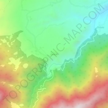
Name: Ovacık topographic map, elevation, terrain.
Location: Ovacık, Ardanuç, Artvin, Black Sea Region, Turkey (41.03302 41.97588 41.07302 42.01588)
Average elevation: 1,258 m
Minimum elevation: 771 m
Maximum elevation: 2,020 m
Thank you for supporting this site ❤️
Make a donation
Make a donation
Gear up for your next adventure:
As an Amazon Associate, this site earns from qualifying purchases at no extra cost to you.