
Thank you for supporting this site ❤️
Make a donation
Make a donation
Gear up for your next adventure:
As an Amazon Associate, this site earns from qualifying purchases at no extra cost to you.
Asumbi topographic map
Click on the map to display elevation.
Thank you for supporting this site ❤️
Make a donation
Make a donation
Gear up for your next adventure:
As an Amazon Associate, this site earns from qualifying purchases at no extra cost to you.
About this map
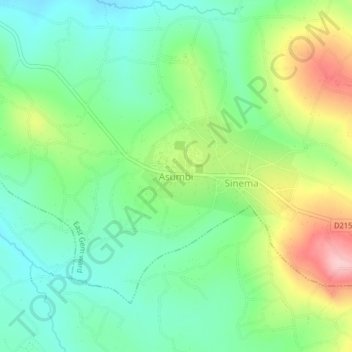
Name: Asumbi topographic map, elevation, terrain.
Location: Asumbi, East Gem ward, Rangwe, Homa Bay County, Kenya (-0.64183 34.59556 -0.60183 34.63556)
Average elevation: 1,403 m
Minimum elevation: 1,342 m
Maximum elevation: 1,520 m
Thank you for supporting this site ❤️
Make a donation
Make a donation
Gear up for your next adventure:
As an Amazon Associate, this site earns from qualifying purchases at no extra cost to you.