Geolocate

Moreno Valley topographic map

Click on the map to display elevation.

About this map

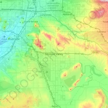
Name: Moreno Valley topographic map, elevation, terrain.

Location: Moreno Valley, Riverside County, California, 92553, United States (33.77752 -117.39059 34.09752 -117.07059)

Average elevation: 494 m

Minimum elevation: 222 m

Maximum elevation: 1,200 m

Other topographic maps

Click on a map to view its topography, its elevation and its terrain.

Gear up for your next adventure:

🔭Compact Binoculars - Lightweight optics for scouting trails and wildlife
🦟Insect Repellent - Keep mosquitoes and black flies away in wooded areas
🥾Approach Boots - Comfortable boots for hiking and climbing approaches
🥾Light Hiking Boots - Lightweight and comfortable boots for day hikes
🥽Outdoor Goggles - Protective eyewear for outdoor activities

As an Amazon Associate, this site earns from qualifying purchases at no extra cost to you.