Geolocate

Grand Junction topographic map

Click on the map to display elevation.

About this map

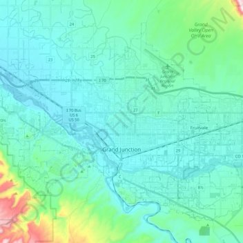
Name: Grand Junction topographic map, elevation, terrain.

Location: Grand Junction, Mesa County, Colorado, United States (39.01863 -108.67572 39.15274 -108.46372)

Average elevation: 1,470 m

Minimum elevation: 1,373 m

Maximum elevation: 2,069 m

Gear up for your next adventure:

🧴Outdoor Sunscreen - High SPF protection for high-altitude UV exposure
Tent Footprint - Protect tent floor and increase durability
🧭GPS Tracker - Track your location in remote areas safely
🚲Heavy Duty Bike Lock - Secure your bike at the trailhead or during stops
🩹Compact First Aid Kit - Pre-packed essentials for common trail injuries

As an Amazon Associate, this site earns from qualifying purchases at no extra cost to you.