
Make a donation
Gear up for your next adventure:
As an Amazon Associate, this site earns from qualifying purchases at no extra cost to you.
Nideggen topographic map
Click on the map to display elevation.
Make a donation
Gear up for your next adventure:
As an Amazon Associate, this site earns from qualifying purchases at no extra cost to you.
Nideggen
In der nachfolgenden Zeit entwickelte sich Nideggen zu einer typisch rheinischen Kleinstadt. 1430 wurde die St. Sebastianus-Schützenbruderschaft gegründet, und 1571 gab es bereits eine Lateinschule. Als 1651 die Franziskaner nach Nideggen kamen, übernahmen diese den höheren Schulunterricht.
Make a donation
Gear up for your next adventure:
As an Amazon Associate, this site earns from qualifying purchases at no extra cost to you.
About this map
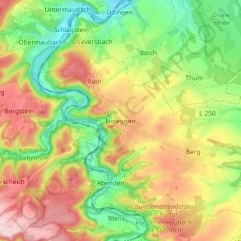
Name: Nideggen topographic map, elevation, terrain.
Location: Nideggen, Kreis Düren, Nordrhein-Westfalen, 52385, Deutschland (50.65136 6.44261 50.73136 6.52261)
Average elevation: 270 m
Minimum elevation: 151 m
Maximum elevation: 429 m
Make a donation
Gear up for your next adventure:
As an Amazon Associate, this site earns from qualifying purchases at no extra cost to you.