Geolocate

Gotarta topographic map

Click on the map to display elevation.

Gotarta

Está situado a 1195 metros de altitud, entre el barranco de Raons y el barranco de l'Oratori. La población era de 30 habitantes en 1970.

Wikipedia (CC-BY-SA 3.0)

About this map

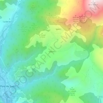
Name: Gotarta topographic map, elevation, terrain.

Location: Gotarta, Pont de Suert, Alta Ribagorza, Cataluña, 25520, España (42.40143 0.74382 42.44143 0.78382)

Average elevation: 1,143 m

Minimum elevation: 828 m

Maximum elevation: 1,863 m

Gear up for your next adventure:

🧦Merino Wool Socks - Moisture-wicking comfort for long-distance hiking
🦶Hiking Shoe Insoles - Added support for high arches and long days on feet
🧦Outdoor Socks - Durable socks designed for hiking and outdoor sports
💡Portable Camping Lamp - Rechargeable lamp for campsite lighting
🧦Hiking Liner Socks - Thin base layer to prevent friction and blisters

As an Amazon Associate, this site earns from qualifying purchases at no extra cost to you.