
Gangtok topographic map
Interactive map
Click on the map to display elevation.
About this map
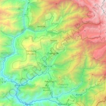
Name: Gangtok topographic map, elevation, terrain.
Location: Gangtok, East Sikkim District, Sikkim, 737101, Inde (27.16905 88.45227 27.48905 88.77227)
Average elevation: 1,911 m
Minimum elevation: 283 m
Maximum elevation: 5,193 m
Gangtok (en népalais. गान्तोक) est la capitale du Sikkim, un ancien royaume himalayen rattaché à l'Inde en 1975 et jouxtant le Tibet, le Népal et le Bhoutan. La ville est située à une altitude de 1 500 m.