Geolocate

Sewod topographic map

Click on the map to display elevation.

About this map

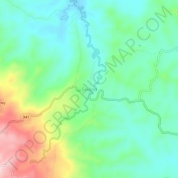
Name: Sewod topographic map, elevation, terrain.

Location: Sewod, Sultan Kudarat, Soccsksargen, 9811, Philippines (6.40320 124.34930 6.44320 124.38930)

Average elevation: 743 m

Minimum elevation: 666 m

Maximum elevation: 922 m

Other topographic maps

Click on a map to view its topography, its elevation and its terrain.

Kabulnan River

Philippines > Sultan Kudarat

Average elevation: 591 m

Columbio

Philippines > Sultan Kudarat

Average elevation: 268 m

Lutayan

Philippines > Sultan Kudarat

Average elevation: 73 m

Kapingkong River

Philippines > Sultan Kudarat > Sampao

Average elevation: 61 m

Gear up for your next adventure:

🧥Thermal Fleece Jacket - Versatile insulation for changing mountain temperatures
🔋Lithium AA Batteries - Long-lasting power that performs in extreme cold
🛌Down Sleeping Bag - Superior warmth-to-weight ratio for cold nights
🛶Canoe Life Vest - Safety vest for water sports
🧴Outdoor Sunscreen - High SPF protection for high-altitude UV exposure

As an Amazon Associate, this site earns from qualifying purchases at no extra cost to you.