
Thank you for supporting this site ❤️
Make a donation
Make a donation
Gear up for your next adventure:
As an Amazon Associate, this site earns from qualifying purchases at no extra cost to you.
Farneta topographic map
Click on the map to display elevation.
Thank you for supporting this site ❤️
Make a donation
Make a donation
Gear up for your next adventure:
As an Amazon Associate, this site earns from qualifying purchases at no extra cost to you.
About this map
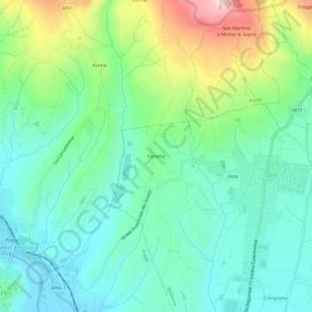
Name: Farneta topographic map, elevation, terrain.
Location: Farneta, Bibbiena, Arezzo, Toscana, 52014, Italia (43.72021 11.77355 43.76021 11.81355)
Average elevation: 447 m
Minimum elevation: 334 m
Maximum elevation: 734 m
Thank you for supporting this site ❤️
Make a donation
Make a donation
Gear up for your next adventure:
As an Amazon Associate, this site earns from qualifying purchases at no extra cost to you.