
Thank you for supporting this site ❤️
Make a donation
Make a donation
Gear up for your next adventure:
As an Amazon Associate, this site earns from qualifying purchases at no extra cost to you.
Völs topographic map
Click on the map to display elevation.
Thank you for supporting this site ❤️
Make a donation
Make a donation
Gear up for your next adventure:
As an Amazon Associate, this site earns from qualifying purchases at no extra cost to you.
About this map
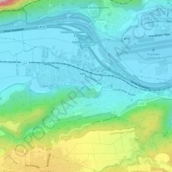
Name: Völs topographic map, elevation, terrain.
Location: Völs, Bezirk Innsbruck-Land, Tirolo, 6176, Austria (47.23986 11.30237 47.26521 11.35209)
Average elevation: 674 m
Minimum elevation: 574 m
Maximum elevation: 872 m
Thank you for supporting this site ❤️
Make a donation
Make a donation
Gear up for your next adventure:
As an Amazon Associate, this site earns from qualifying purchases at no extra cost to you.