Geolocate

Bend topographic map

Click on the map to display elevation.

About this map

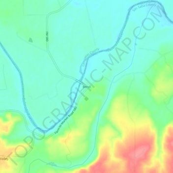
Name: Bend topographic map, elevation, terrain.

Location: Bend, San Saba County, Texas, United States (31.07934 -98.53281 31.11934 -98.49281)

Average elevation: 350 m

Minimum elevation: 324 m

Maximum elevation: 407 m

Other topographic maps

Click on a map to view its topography, its elevation and its terrain.

Simpson Creek

United States > Texas > San Saba County

Average elevation: 366 m

San Saba

United States > Texas > San Saba County

Average elevation: 391 m

Gear up for your next adventure:

🥾Lightweight Hiking Shoes - Comfortable shoes for day hikes
🔨Vehicle Emergency Tool - Safety tool for remote road trips to trailheads
🪑Insulated Seat Pad - Protect your seat from cold rocks and wet logs
🧥Softshell Jacket - Windproof and breathable jacket for hiking
🧢Beanie Hat - Keep your head warm in cold weather

As an Amazon Associate, this site earns from qualifying purchases at no extra cost to you.