
Thank you for supporting this site ❤️
Make a donation
Make a donation
Gear up for your next adventure:
As an Amazon Associate, this site earns from qualifying purchases at no extra cost to you.
Middletown topographic map
Click on the map to display elevation.
Thank you for supporting this site ❤️
Make a donation
Make a donation
Gear up for your next adventure:
As an Amazon Associate, this site earns from qualifying purchases at no extra cost to you.
About this map
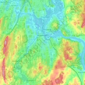
Name: Middletown topographic map, elevation, terrain.
Location: Middletown, Middlesex County, Connecticut, United States (41.49484 -72.75294 41.60432 -72.55095)
Average elevation: 76 m
Minimum elevation: -1 m
Maximum elevation: 262 m
Thank you for supporting this site ❤️
Make a donation
Make a donation
Gear up for your next adventure:
As an Amazon Associate, this site earns from qualifying purchases at no extra cost to you.
Other topographic maps
Click on a map to view its topography, its elevation and its terrain.
Newfield Heights
United States > Connecticut > Middlesex County > Middletown > Newfield Heights
Average elevation: 42 m