Geolocate

Bonito topographic map

Click on the map to display elevation.

About this map

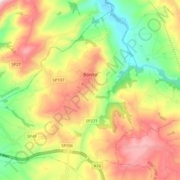
Name: Bonito topographic map, elevation, terrain.

Location: Bonito, Terre dell’Ufita, Avellino, Campania, Italy (41.06758 14.94475 41.11810 15.01973)

Average elevation: 397 m

Minimum elevation: 203 m

Maximum elevation: 603 m

Other topographic maps

Click on a map to view its topography, its elevation and its terrain.

Quaglietta

Italy > Campania > Avellino > Calabritto

Average elevation: 320 m

Santa Barbara

Italy > Campania > Avellino > Ariano Irpino

Average elevation: 461 m

Ariano Scalo

Italy > Campania > Avellino > Ariano Irpino

Average elevation: 576 m

Gear up for your next adventure:

🥘Camping Cookware Set - Compact nesting pots and pans for trail cooking
🥾Durable Hiking Shoes - Long-lasting shoes for frequent hiking
Lightweight Camping Tent - Portable shelter optimized for Canadian backcountry camping
💧Hydration Bladder - Hands-free hydration solution for long treks
🎒Fully Waterproof Backpack - Total protection for photography gear and electronics

As an Amazon Associate, this site earns from qualifying purchases at no extra cost to you.