Geolocate

Linapew topographic map

Click on the map to display elevation.

About this map

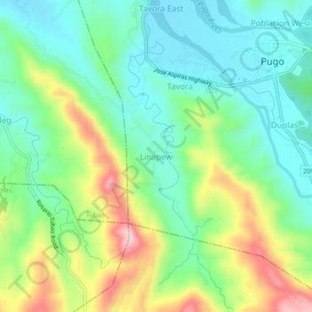
Name: Linapew topographic map, elevation, terrain.

Location: Linapew, Pugo, La Union, Ilocos Region, 2508, Philippines (16.28805 120.43179 16.32805 120.47179)

Average elevation: 138 m

Minimum elevation: 44 m

Maximum elevation: 329 m

Gear up for your next adventure:

Tent Footprint - Protect tent floor and increase durability
🎒Hiking Daypack - Lightweight and durable backpacks for day trips and excursions
🔨Vehicle Emergency Tool - Safety tool for remote road trips to trailheads
🦌Outdoor Trail Camera - Monitor wildlife activity near your favorite spots
🏕️Camping Hammock - Integrated protection for sleeping between trees

As an Amazon Associate, this site earns from qualifying purchases at no extra cost to you.