Geolocate

Steig topographic map

Click on the map to display elevation.

Steig

Der Ortsname stammt vom mittelhochdeutschen Wort steig(e) für steile Straße bzw. Anhöhe ab.

Wikipedia (CC-BY-SA 3.0)

About this map

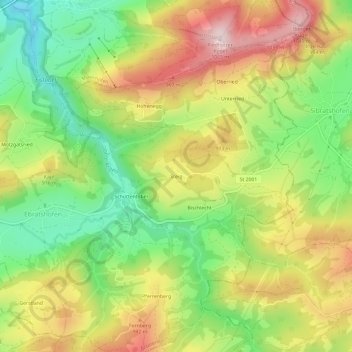
Name: Steig topographic map, elevation, terrain.

Location: Steig, Grünenbach, Argental (VGem), Landkreis Lindau, Bayern, 88167, Deutschland (47.60201 10.03605 47.64201 10.07605)

Average elevation: 844 m

Minimum elevation: 665 m

Maximum elevation: 1,051 m

Other topographic maps

Click on a map to view its topography, its elevation and its terrain.

88167

Deutschland > Bayern > Landkreis Lindau > Grünenbach > Laubenberg

Average elevation: 758 m

Gear up for your next adventure:

🧢Sun Hat - Wide-brim hat for sun protection
🥾Mountaineering Boots - Supportive boots for climbing and high-altitude hiking
🎒Hiking Backpack - Lightweight and ergonomic backpacks for day hikes or multi-day treks
🧥Insulated Jacket - Keep warm in cold outdoor conditions
🧢Outdoor Visor - Breathable visor for sunny hikes

As an Amazon Associate, this site earns from qualifying purchases at no extra cost to you.