Geolocate

Mokai topographic map

Click on the map to display elevation.

About this map

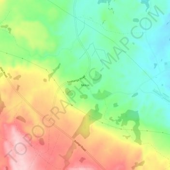
Name: Mokai topographic map, elevation, terrain.

Location: Mokai, Taupō District, Waikato, New Zealand (-38.54878 175.88384 -38.50878 175.92384)

Average elevation: 545 m

Minimum elevation: 446 m

Maximum elevation: 676 m

Other topographic maps

Click on a map to view its topography, its elevation and its terrain.

Hauhungaroa Range

New Zealand > Waikato > Taupo District

Average elevation: 753 m

Tongariro River

New Zealand > Waikato > Taupo District

Average elevation: 853 m

Lake Rotoaira

New Zealand > Waikato > Taupo District

Average elevation: 624 m

Lake Rotokawa

New Zealand > Waikato > Taupo District

Average elevation: 358 m

Lake Rotopounamu

New Zealand > Waikato > Taupo District

Average elevation: 784 m

Summit Plateau

New Zealand > Waikato > Taupo District

Average elevation: 2,454 m

Motutaiko Island

New Zealand > Waikato > Taupo District

Average elevation: 357 m

Gear up for your next adventure:

🧊Insulated Water Bottle - Keeps drinks cold in summer and prevents freezing in winter
🛶Kayak Accessories - Essential gear for safe and fun kayaking adventures
🥾Trail Hiking Boots - Supportive boots for rough trails
🩹Moleskin Blister Pads - Direct protection for painful foot pressure points
🧰Survival Kit - Essential gear for emergencies in the wilderness

As an Amazon Associate, this site earns from qualifying purchases at no extra cost to you.