Geolocate

Moritzburg topographic map

Click on the map to display elevation.

About this map

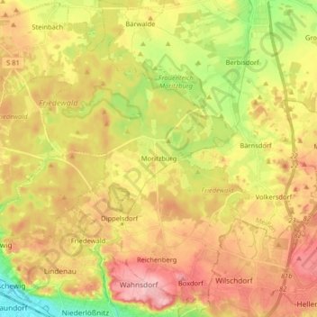
Name: Moritzburg topographic map, elevation, terrain.

Location: Moritzburg, Meißen, Saxony, 01468, Germany (51.10847 13.59375 51.20959 13.72814)

Average elevation: 182 m

Minimum elevation: 106 m

Maximum elevation: 249 m

Gear up for your next adventure:

🥾Lightweight Hiking Boots - Boots for comfort and mobility on long hikes
🕶️Polarized Sunglasses - Reduces glare from snow and water at high elevations
🔦LED Flashlight - Powerful and long-lasting flashlight for camping and emergencies
🥾All-Terrain Hiking Boots - Versatile boots for varied hiking conditions
🥾Waterproof Trail Shoes - Shoes designed to handle wet terrain

As an Amazon Associate, this site earns from qualifying purchases at no extra cost to you.