Geolocate

Riedstadt topographic map

Click on the map to display elevation.

About this map

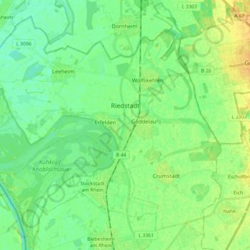
Name: Riedstadt topographic map, elevation, terrain.

Location: Riedstadt, Kreis Groß-Gerau, Hesse, 64560, Germany (49.78484 8.37634 49.88249 8.54962)

Average elevation: 90 m

Minimum elevation: 81 m

Maximum elevation: 103 m

Gear up for your next adventure:

🛶Waterproof Dry Bags - Keep electronics and clothes dry during river crossings
🔋Emergency Crank Radio - Weather alerts and power without needing batteries
🥾Waterproof Trail Shoes - Shoes designed to handle wet terrain
🛰️Satellite Messenger - Emergency communication for areas with no cell service
🕯️Camping Lantern - Illuminates your entire campsite with high-efficiency LEDs

As an Amazon Associate, this site earns from qualifying purchases at no extra cost to you.