Geolocate

Ringwood topographic map

Click on the map to display elevation.

About this map

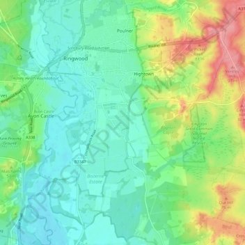
Name: Ringwood topographic map, elevation, terrain.

Location: Ringwood, New Forest, Hampshire, England, United Kingdom (50.79615 -1.81214 50.86265 -1.73266)

Average elevation: 34 m

Minimum elevation: 6 m

Maximum elevation: 96 m

Gear up for your next adventure:

🪑Ultralight Camping Stool - Compact seating for rest stops during long hikes
💡LED Headlamp - Hands-free illumination for night hiking and camping
🧥Softshell Hiking Jacket - The perfect balance of wind protection and breathability
🥘Camping Cookware Set - Compact nesting pots and pans for trail cooking
🚲Bike Repair Kit - Essential tools for on-trail mechanical issues

As an Amazon Associate, this site earns from qualifying purchases at no extra cost to you.