
Parsan topographic map
Click on the map to display elevation.
About this map
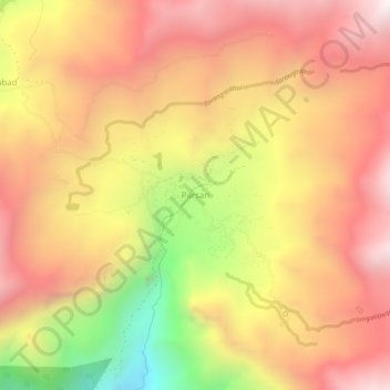
Name: Parsan topographic map, elevation, terrain.
Average elevation: 3,042 m
Minimum elevation: 2,222 m
Maximum elevation: 3,583 m
Other topographic maps
Click on a map to view its topography, its elevation and its terrain.
Upper Gazikistan Glacier
Pakistan > Khyber Pakhtunkhwa > Chitrāl District > Chitral Tehsil
Average elevation: 5,086 m
Bamburait River
Pakistan > Khyber Pakhtunkhwa > Chitrāl District > Chitral Tehsil
Average elevation: 2,999 m