Geolocate

Tamayo topographic map

Click on the map to display elevation.

About this map

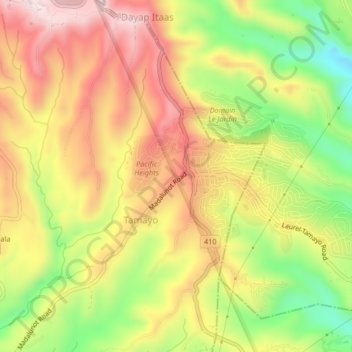
Name: Tamayo topographic map, elevation, terrain.

Location: Tamayo, Calaca, Batangas, Calabarzon, Philippines (14.01740 120.83561 14.05740 120.87561)

Average elevation: 442 m

Minimum elevation: 214 m

Maximum elevation: 637 m

Gear up for your next adventure:

🧴First Aid Kit - Essential first aid supplies for outdoor emergencies
🧦Crew Hiking Socks - Comfortable socks for long-distance hikes
🧥Ultralight Puffy Jacket - Maximum warmth that packs down to the size of an orange
💧Filtered Water Bottle - Safe drinking water on the go
Family Camping Tent - Spacious tent suitable for family camping trips

As an Amazon Associate, this site earns from qualifying purchases at no extra cost to you.