
Las Mercedes topographic map
Click on the map to display elevation.
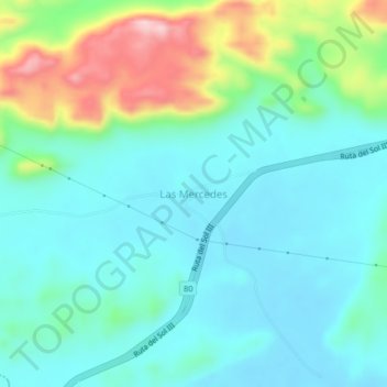
About this map
Name: Las Mercedes topographic map, elevation, terrain.
Location: Las Mercedes, Valledupar, Cesar, RAP Caribe, Colombia (10.04983 -73.79681 10.08983 -73.75681)
Average elevation: 162 m
Minimum elevation: 98 m
Maximum elevation: 362 m
Other topographic maps
Click on a map to view its topography, its elevation and its terrain.
Perímetro Urbano Valledupar
Colombia > Cesar > Valledupar
Su territorio es llano y basculado hacia el suroriente mediante una leve pendiente. La ciudad se encuentra a una altitud que oscila entre los 246 m al norte (Planta de Tratamiento de Agua Potable) y 150 m al Sur (conjunto habitacional Casa de Campo), la altitud media es de 168 m (Plaza Alfonso López). Además…
Average elevation: 163 m