Geolocate

Kohora topographic map

Click on the map to display elevation.

About this map

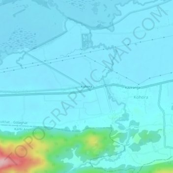
Name: Kohora topographic map, elevation, terrain.

Location: Kohora, Kohara, Bokakhat, Golaghat, Assam, 785609, India (26.56945 93.37646 26.60945 93.41646)

Average elevation: 96 m

Minimum elevation: 68 m

Maximum elevation: 348 m

Gear up for your next adventure:

🥾Light Hiking Boots - Lightweight and comfortable boots for day hikes
🥽Outdoor Goggles - Protective eyewear for outdoor activities
🛰️Satellite Messenger - Emergency communication for areas with no cell service
🛶Canoe Life Vest - Safety vest for water sports
🧤Thermal Hiking Gloves - Grip-enhanced gloves for cold-weather altitude trekking

As an Amazon Associate, this site earns from qualifying purchases at no extra cost to you.