
La Corniche topographic map
Interactive map
Click on the map to display elevation.
About this map
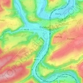
Name: La Corniche topographic map, elevation, terrain.
Location: La Corniche, Esneux, Liège, Wallonie, 4130, Belgique (50.50664 5.54637 50.54664 5.58637)
Average elevation: 156 m
Minimum elevation: 74 m
Maximum elevation: 264 m
Other topographic maps
Click on a map to view its topography, its elevation and its terrain.
Château Brunsode
Belgique > Liège > Liège > Esneux > Tilff > Sur-le-Mont
Château Brunsode, 2, Domaine Brunsode, Sur-le-Mont, Tilff, Esneux, Liège, Wallonie, 4130, Belgique
Average elevation: 156 m