Geolocate

Tanggul topographic map

Click on the map to display elevation.

About this map

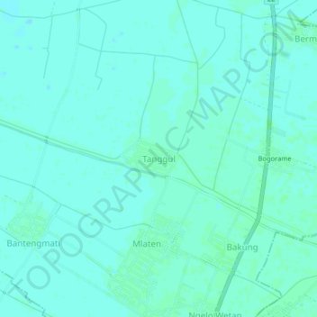
Name: Tanggul topographic map, elevation, terrain.

Location: Tanggul, Mijen, Demak, Central Java, Java, Indonesia (-6.84376 110.69305 -6.80376 110.73305)

Average elevation: 5 m

Minimum elevation: 2 m

Maximum elevation: 7 m

Other topographic maps

Click on a map to view its topography, its elevation and its terrain.

Mijen

Indonesia > Central Java > Demak

Average elevation: 5 m

Karanganyar

Indonesia > Central Java > Demak

Average elevation: 7 m

Kali Tuntang

Indonesia > Central Java > Demak > Bonangrejo

Average elevation: 4 m

Bonang

Indonesia > Central Java > Demak

Average elevation: 3 m

Kali Tulung

Indonesia > Central Java > Demak > Gebangarum

Average elevation: 3 m

Gear up for your next adventure:

🔦LED Headtorch - Bright and durable light for night activities
Family Camping Tent - Spacious tent suitable for family camping trips
🎒Hiking Backpack - Lightweight and ergonomic backpacks for day hikes or multi-day treks
🧢Outdoor Cap - Protective cap for sun and rain during hikes
🔋Solar Power Bank - Keep your GPS and devices charged during long outdoor trips

As an Amazon Associate, this site earns from qualifying purchases at no extra cost to you.