
Heilbronn topographic map
Click on the map to display elevation.
About this map
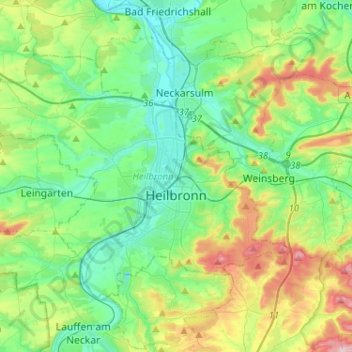
Name: Heilbronn topographic map, elevation, terrain.
Location: Heilbronn, Baden-Württemberg, Germany (49.09289 9.04444 49.20992 9.30208)
Average elevation: 220 m
Minimum elevation: 143 m
Maximum elevation: 415 m
Other topographic maps
Click on a map to view its topography, its elevation and its terrain.
Roggensee
Germany > Baden-Württemberg > Landkreis Biberach > Bad Schussenried
Average elevation: 661 m
Dettingen
Germany > Baden-Württemberg > Landkreis Tübingen > Rottenburg am Neckar
Average elevation: 464 m